


软件

产品


esriFeatureType通常用来表示 数据 的存储结构,即 物理 层;
esriGeometryType通常用来表示数据的几何形状,即表现层。
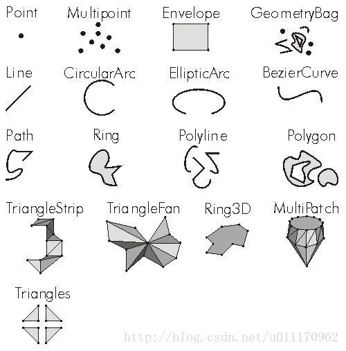
esriGeometryType枚举类型详解
| 常量 | 值 | 对象 |
| esriGeometryNull | 0 | 未知类型(Unknown) |
| esriGeometryPoint | 1 | 点(Point) |
| esriGeometryMultipoint | 2 | 多点(Multipoint) |
| esriGeometryLine | 13 | 线段(Line) |
| esriGeometryCircularArc | 14 | 圆弧(CircularArc) |
| esriGeometryEllipticArc | 16 | 椭圆弧(EllipticArc) |
| esriGeometryBezier3Curve | 15 | 贝兹曲线(BezierCurve) |
| esriGeometryPath | 6 | 路径(Path) |
| esriGeometryPolyline | 3 | 多段线(Polyline) |
| esriGeometryRing | 11 | 环(Ring) |
| esriGeometryPolygon | 4 | 多边形(Polygon) |
| esriGeometryEnvelope | 5 | 外包(Envelope) |
| esriGeometryAny | 7 | 任何类型(Any valid geometry) |
| esriGeometryBag | 17 | 任意几何类型的集合(GeometryBag) |
| esriGeometryMultiPatch | 9 | 表面几何(MultiPatch) |
| esriGeometryTriangleStrip | 18 | 三角带(TriangleStrip) |
| esriGeometryTriangleFan | 19 | 三角扇形(TriangleFan) |
| esriGeometryRay | 20 | 射线(Ray) |
| esriGeometrySphere | 21 | 球体(Sphere) |
| esriGeometryTriangles | 22 | 三角形(Triangles) |
| esriFeatureType枚举类型详解 | |||
| 常量 | 值 | 描述 | 对象 |
| esriFTSimple | 1 | Polygons, polylines, and points representing objects or places that have area, such as water bodies; linear objects, such as rivers; and localized positions, such as houses or sample sites. | Simple Feature. |
| esriFTSimpleJunction | 7 | Simple junction feature in a geometric network representing point objects, such as a fuse, service point, or telephone pole. | Simple Junction Feature. |
| esriFTSimpleEdge | 8 | Simple edge feature in a geometric network representing polyline objects, such as primary or secondary overheads. | Simple Edge Feature. |
| esriFTComplexJunction | 9 | Complex junction feature in a geometric network, not in general use. | Complex Junction Feature. |
| esriFTComplexEdge | 10 | Complex edge feature in a geometric network representing polyline objects such as primary overheads, which have midspan connectivity. Network resources flow through complex edge without interruption by midspan connectivity. | Complex Edge Feature. |
| esriFTAnnotation | 11 | Place or object names or identifiers, such as street names, hydrant ID numbers, land values, or elevation. | Annotation Feature. |
| esriFTCoverageAnnotation | 12 | Place or object names or identifiers, such as street names, hydrant ID numbers, land values, or elevation. Not supported in geodatabases, only supported in coverage datasets. | Coverage Annotation Feature. |
| esriFTDimension | 13 | Measurements, such as distances, lengths, widths, and depths. | Dimension Feature. |
| esriFTRasterCatalogItem | 14 | A raster dataset in a raster catalog that has information, such as footprints, names, metadata, and any other user-defined attributes. | Raster Catalog Item. |
免责声明:本文系网络转载或改编,未找到原创作者,版权归原作者所有。如涉及版权,请联系删
 技术文档
技术文档
 推荐好文
推荐好文


 155-2731-8020


