


软件

产品


最近公司让我做arcgis的调研,哎,作为一名 java工程师 ,只能什么都要学上一下!还是留下点足迹。arcgis前台一定需要一些样式按钮。我也没找到关于arcgis按钮样式的介绍,自己就整理了下记录下来。
先看看有哪些
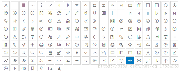
不说了,撸 代码 !
<!DOCTYPE html><html lang="en"><head><meta charset="utf-8"><meta name="viewport" content="initial-scale=1,maximum-scale=1,user-scalable=no"><title>ARCGIS API 所有按钮</title><link rel="stylesheet" href="http://172.16.1.120:8090/arcgis_js_api/library/4.8/esri/css/main.css"><style>.action-button {font-size: 16px;background-color: transparent;border: 1px solid #D3D3D3;color: #6e6e6e;height: 32px;width: 32px;text-align: center;box-shadow: 0 0 1px rgba(0, 0, 0, 0.3);} .action-button:hover,.action-button:focus {background: #0079c1;color: #e4e4e4;}</style></head><body><div><button class="action-button esri-icon-close" type="button" title=""></button><button class="action-button esri-icon-drag-horizontal" type="button" title=""></button><button class="action-button esri-icon-drag-vertical" type="button" title=""></button><button class="action-button esri-icon-handle-horizontal" type="button" title=""></button><button class="action-button esri-icon-handle-vertical" type="button" title=""></button><button class="action-button esri-icon-check-mark" type="button" title=""></button><button class="action-button esri-icon-left-triangle-arrow" type="button" title=""></button><button class="action-button esri-icon-right-triangle-arrow" type="button" title=""></button><button class="action-button esri-icon-down-arrow" type="button" title=""></button><button class="action-button esri-icon-up-arrow" type="button" title=""></button><button class="action-button esri-icon-overview-arrow-bottom-left" type="button" title=""></button><button class="action-button esri-icon-overview-arrow-bottom-right" type="button" title=""></button><button class="action-button esri-icon-overview-arrow-top-left" type="button" title=""></button><button class="action-button esri-icon-overview-arrow-top-right" type="button" title=""></button><button class="action-button esri-icon-maximize" type="button" title=""></button><button class="action-button esri-icon-minimize" type="button" title=""></button><button class="action-button esri-icon-checkbox-unchecked" type="button" title=""></button><button class="action-button esri-icon-checkbox-checked" type="button" title=""></button><button class="action-button esri-icon-radio-unchecked" type="button" title=""></button><button class="action-button esri-icon-radio-checked" type="button" title=""></button><button class="action-button esri-icon-up-arrow-circled" type="button" title=""></button><button class="action-button esri-icon-down-arrow-circled" type="button" title=""></button><button class="action-button esri-icon-left-arrow-circled" type="button" title=""></button><button class="action-button esri-icon-right-arrow-circled" type="button" title=""></button><button class="action-button esri-icon-zoom-out-fixed" type="button" title=""></button><button class="action-button esri-icon-zoom-in-fixed" type="button" title=""></button><button class="action-button esri-icon-refresh" type="button" title=""></button><button class="action-button esri-icon-edit" type="button" title=""></button><button class="action-button esri-icon-authorize" type="button" title=""></button><button class="action-button esri-icon-map-pin" type="button" title=""></button><button class="action-button esri-icon-blank-map-pin" type="button" title=""></button><button class="action-button esri-icon-table" type="button" title=""></button><button class="action-button esri-icon-plus" type="button" title=""></button><button class="action-button esri-icon-minus" type="button" title=""></button><button class="action-button esri-icon-beginning" type="button" title=""></button><button class="action-button esri-icon-reverse" type="button" title=""></button><button class="action-button esri-icon-pause" type="button" title=""></button><button class="action-button esri-icon-play" type="button" title=""></button><button class="action-button esri-icon-forward" type="button" title=""></button><button class="action-button esri-icon-end" type="button" title=""></button><button class="action-button esri-icon-erase" type="button" title=""></button><button class="action-button esri-icon-up-down-arrows" type="button" title=""></button><button class="action-button esri-icon-left" type="button" title=""></button><button class="action-button esri-icon-right" type="button" title=""></button><button class="action-button esri-icon-announcement" type="button" title=""></button><button class="action-button esri-icon-notice-round" type="button" title=""></button><button class="action-button esri-icon-notice-triangle" type="button" title=""></button><button class="action-button esri-icon-home" type="button" title=""></button><button class="action-button esri-icon-locate" type="button" title=""></button><button class="action-button esri-icon-expand" type="button" title=""></button><button class="action-button esri-icon-collapse" type="button" title=""></button><button class="action-button esri-icon-layer-list" type="button" title=""></button><button class="action-button esri-icon-basemap" type="button" title=""></button><button class="action-button esri-icon-globe" type="button" title=""></button><button class="action-button esri-icon-applications" type="button" title=""></button><button class="action-button esri-icon-arrow-up-circled" type="button" title=""></button><button class="action-button esri-icon-arrow-down-circled" type="button" title=""></button><button class="action-button esri-icon-arrow-left-circled" type="button" title=""></button><button class="action-button esri-icon-arrow-right-circled" type="button" title=""></button><button class="action-button esri-icon-minus-circled" type="button" title=""></button><button class="action-button esri-icon-plus-circled" type="button" title=""></button><button class="action-button esri-icon-add-attachment" type="button" title=""></button><button class="action-button esri-icon-attachment" type="button" title=""></button><button class="action-button esri-icon-calendar" type="button" title=""></button><button class="action-button esri-icon-close-circled" type="button" title=""></button><button class="action-button esri-icon-browser" type="button" title=""></button><button class="action-button esri-icon-collection" type="button" title=""></button><button class="action-button esri-icon-comment" type="button" title=""></button><button class="action-button esri-icon-configure-popup" type="button" title=""></button><button class="action-button esri-icon-contact" type="button" title=""></button><button class="action-button esri-icon-dashboard" type="button" title=""></button><button class="action-button esri-icon-deny" type="button" title=""></button><button class="action-button esri-icon-description" type="button" title=""></button><button class="action-button esri-icon-directions" type="button" title=""></button><button class="action-button esri-icon-directions2" type="button" title=""></button><button class="action-button esri-icon-documentation" type="button" title=""></button><button class="action-button esri-icon-duplicate" type="button" title=""></button><button class="action-button esri-icon-review" type="button" title=""></button><button class="action-button esri-icon-environment-settings" type="button" title=""></button><button class="action-button esri-icon-error" type="button" title=""></button><button class="action-button esri-icon-error2" type="button" title=""></button><button class="action-button esri-icon-experimental" type="button" title=""></button><button class="action-button esri-icon-feature-layer" type="button" title=""></button><button class="action-button esri-icon-filter" type="button" title=""></button><button class="action-button esri-icon-grant" type="button" title=""></button><button class="action-button esri-icon-group" type="button" title=""></button><button class="action-button esri-icon-key" type="button" title=""></button><button class="action-button esri-icon-labels" type="button" title=""></button><button class="action-button esri-icon-tag" type="button" title=""></button><button class="action-button esri-icon-layers" type="button" title=""></button><button class="action-button esri-icon-left-arrow" type="button" title=""></button><button class="action-button esri-icon-right-arrow" type="button" title=""></button><button class="action-button esri-icon-link-external" type="button" title=""></button><button class="action-button esri-icon-link" type="button" title=""></button><button class="action-button esri-icon-loading-indicator" type="button" title=""></button><button class="action-button esri-icon-maps" type="button" title=""></button><button class="action-button esri-icon-marketplace" type="button" title=""></button><button class="action-button esri-icon-media" type="button" title=""></button><button class="action-button esri-icon-media2" type="button" title=""></button><button class="action-button esri-icon-menu" type="button" title=""></button><button class="action-button esri-icon-mobile" type="button" title=""></button><button class="action-button esri-icon-phone" type="button" title=""></button><button class="action-button esri-icon-navigation" type="button" title=""></button><button class="action-button esri-icon-pan" type="button" title=""></button><button class="action-button esri-icon-printer" type="button" title=""></button><button class="action-button esri-icon-pie-chart" type="button" title=""></button><button class="action-button esri-icon-chart" type="button" title=""></button><button class="action-button esri-icon-line-chart" type="button" title=""></button><button class="action-button esri-icon-question" type="button" title=""></button><button class="action-button esri-icon-resend-invitation" type="button" title=""></button><button class="action-button esri-icon-rotate" type="button" title=""></button><button class="action-button esri-icon-save" type="button" title=""></button><button class="action-button esri-icon-settings" type="button" title=""></button><button class="action-button esri-icon-settings2" type="button" title=""></button><button class="action-button esri-icon-share" type="button" title=""></button><button class="action-button esri-icon-sign-out" type="button" title=""></button><button class="action-button esri-icon-support" type="button" title=""></button><button class="action-button esri-icon-user" type="button" title=""></button><button class="action-button esri-icon-time-clock" type="button" title=""></button><button class="action-button esri-icon-trash" type="button" title=""></button><button class="action-button esri-icon-upload" type="button" title=""></button><button class="action-button esri-icon-download" type="button" title=""></button><button class="action-button esri-icon-zoom-in-magnifying-glass" type="button" title=""></button><button class="action-button esri-icon-search" type="button" title=""></button><button class="action-button esri-icon-zoom-out-magnifying-glass" type="button" title=""></button><button class="action-button esri-icon-locked" type="button" title=""></button><button class="action-button esri-icon-unlocked" type="button" title=""></button><button class="action-button esri-icon-favorites" type="button" title=""></button><button class="action-button esri-icon-compass" type="button" title=""></button><button class="action-button esri-icon-down" type="button" title=""></button><button class="action-button esri-icon-up" type="button" title=""></button><button class="action-button esri-icon-chat" type="button" title=""></button><button class="action-button esri-icon-dock-bottom" type="button" title=""></button><button class="action-button esri-icon-dock-left" type="button" title=""></button><button class="action-button esri-icon-dock-right" type="button" title=""></button><button class="action-button esri-icon-organization" type="button" title=""></button><button class="action-button esri-icon-north-navigation" type="button" title=""></button><button class="action-button esri-icon-locate-circled" type="button" title=""></button><button class="action-button esri-icon-dial" type="button" title=""></button><button class="action-button esri-icon-polygon" type="button" title=""></button><button class="action-button esri-icon-polyline" type="button" title=""></button><button class="action-button esri-icon-visible" type="button" title=""></button><button class="action-button esri-icon-non-visible" type="button" title=""></button><button class="action-button esri-icon-link-vertical" type="button" title=""></button><button class="action-button esri-icon-unlocked-link-vertical" type="button" title=""></button><button class="action-button esri-icon-link-horizontal" type="button" title=""></button><button class="action-button esri-icon-unlocked-link-horizontal" type="button" title=""></button><button class="action-button esri-icon-swap" type="button" title=""></button><button class="action-button esri-icon-cta-link-external" type="button" title=""></button><button class="action-button esri-icon-reply" type="button" title=""></button><button class="action-button esri-icon-public" type="button" title=""></button><button class="action-button esri-icon-share2" type="button" title=""></button><button class="action-button esri-icon-launch-link-external" type="button" title=""></button><button class="action-button esri-icon-rotate-back" type="button" title=""></button><button class="action-button esri-icon-pan2" type="button" title=""></button><button class="action-button esri-icon-tracking" type="button" title=""></button><button class="action-button esri-icon-expand2" type="button" title=""></button><button class="action-button esri-icon-arrow-down" type="button" title=""></button><button class="action-button esri-icon-arrow-up" type="button" title=""></button><button class="action-button esri-icon-hollow-eye" type="button" title=""></button><button class="action-button esri-icon-play-circled" type="button" title=""></button><button class="action-button esri-icon-volume-off" type="button" title=""></button><button class="action-button esri-icon-volume-on" type="button" title=""></button><button class="action-button esri-icon-bookmark" type="button" title=""></button><button class="action-button esri-icon-lightbulb" type="button" title=""></button><button class="action-button esri-icon-sketch-rectangle" type="button" title=""></button><button class="action-button esri-icon-north-navigation-filled" type="button" title=""></button> </div></body></html>
免责声明:本文系网络转载或改编,未找到原创作者,版权归原作者所有。如涉及版权,请联系删
 技术文档
技术文档
 推荐好文
推荐好文


 155-2731-8020


